Agro Climatic Regions of Bihar
■ Agro-Climatic Zones
Bihar falls in the Agro Climatic Zone IV, which is called Middle Gangetic Plains Region.
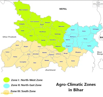
Based on rainfall, temperature, soil and terrain, the state is divided into three agro-climatic zones, these are:
- Zone I: North-West alluvial plains,
- Zone II: North-East alluvial plains, and
- Zone III: South Bihar alluvial plains
Zone III is further sub-divided into Zone IIIA: Southern East and Zone IIIB: Southern West
 |
■ Zone I: North-West alluvial plains:
The North-west alluvial plain is located to the north of the River Ganges. This sub-zone is at the foot of the Himalaya and receives an average annual rainfall of 1245 mm. The climate is dry to moist sub-humid and the soil type is mainly loam and sandy loam.
The land's slope is slightly tilted towards the south-east direction with a very low gradient as evidenced by the direction in which the rivers flow. However, the rivers move in the eastward direction along the natural levee before they finally meet the Ganges. As a result, there are vast waterlogged areas in the districts of Saran, Vaishali and Samastipur. Due to near flatness of the landscape, the vast area gets flooded during monsoon.
Except for the northern portion and portion in the west of the zone under the influence of Adhwara group of rivers, the entire zone is under the influence of rivers like Gandak, Burhi Gandak and Ghaghra, all of which originate in the lime-rich foothills of the Himalayas.
Thus, the soil under the influence of Gandak, Burhi Gandak and Ghaghra are mostly calcareous having different amounts of lime in them. As a result, the soil of near flatlands of East and West Champaran and Muzaffarpur are also salt-affected. The soils of the northern part not under the influence of the above rivers are neutral, acidic or saline depending on the microrelief and local physiography.
■ Zone II: North-East alluvial plains:
This zone lies in the alluvial plains of Kosi, Mahananda and its tributaries and Ganga (a narrow strip in the south) is slightly undulating to rolling landscape mixed with long stretches of nearly flat landscape with pockets of areas having subnormal relief. The area is full of streams with abandoned dead channels of Kosi river, which becomes notorious for its frequent and sudden change of courses forming small lakes and shallow marshes.
In the south, in between the natural levees of Ganga, on the one hand, and Kosi and Mahananda on the other, there are vast areas which remain waterlogged for a considerable part of the year.
The general slope of the land is towards south-east and the rivers on reaching Ganga moves eastward for a long distance before they meet river Ganga.
Unlike the rivers Gandak and Ghaghra, Kosi and Mahananda originate and have catchments in the Himalayan region, which are not calcareous but rich in acidic minerals. As a result, the soils of this zone are noncalcareous, accumulation of sodium salts and sodium adsorption has taken place in areas where the drainage is poor. Salinity and alkalinity are, however, on an increase in Saharsa and western part of Purnea and Katihar districts. As both Kosi and Mahananda carry a tremendous load of sediments, the soils are mostly light-textured except in backwaters of river Ganga and Kosi.
The North-East Zone receives the highest amount of annual precipitation with an annual average of 1,450 mm and the climate is similar to other sub-zones in the Bihar plains i.e. dry to moist subhumid.
■ Zone III: South Bihar alluvial plains
This zone is the alluvial plains of river Ganga on its southern side and the sediments are received both from river Ganga and those flowing from the south having their origins in the Chotanagpur Plateau, which rise abruptly from the plains.
The land’s slope is towards the northeast with gentle slope gradient and moderate to low gradient. In the south of the natural levee of the Ganga, there is a vast stretch of backwaters known as ‚Tal lands extending from Buxar to Pirpaity, where most of the rivers and rivulets coming from the south get lost. The flood plains of Ganga, which get reworked and get eroded and deposited at regular intervals due to river's changing course, are lighter than ‚Tal lands and are known locally as Diara lands. Diara is a land situated between natural levees or embankments and floods are an annual feature in diaras.
The river originating from the Chotanagpur plateau brings a lot of fine sediments. The coarser sediments that they bring are either deposited in their beds or on their banks and as a consequence, the soils are mostly medium to heavy textured throughout the depth of the profiled. There are no marshy lands in this zone.
This region receives an average annual rainfall of 1115 mm and unlike other zones, it is prone to droughts.
■ Extra links:
The End.


